
/
1
2
3
4
5
6
·
·
·
·
·
·
A Faroese adventure starts way before the wheels of the plane meet the runway, the first deed is working out which network of transportation can assist you in reaching this maze of islands in the Atlantic Ocean.
We opted for the 500 mile road trip from Devon to Edinburgh followed by a short Atlantic Airways flight to Vágar, the only airport in the Faroe Islands. As the flight approaches the islands, through broken cloud we spotted the unique and dramatic landscape erupt from the ocean. Views of waves crashing against huge mountains covered in a mossy green coat causes your jaw to drop from its usual position.
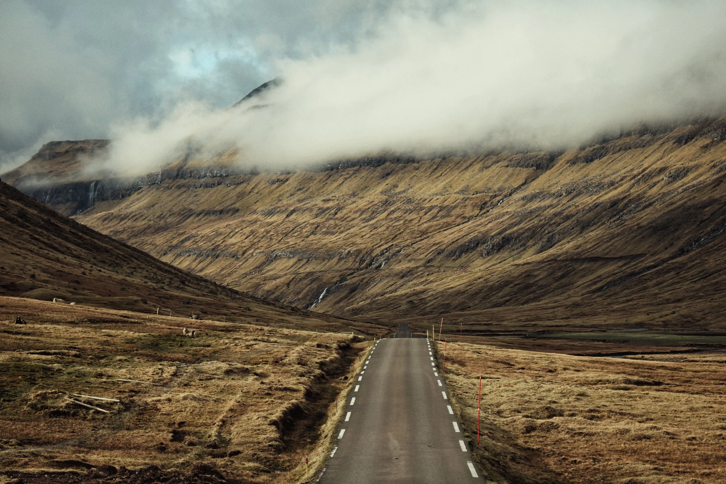
After landing we picked up our car and hit the road heading for Klaksvik, within thirty seconds the road began to hug the edge of Sørvágsvatn Lake, the largest lake in the Faroe Islands, within sixty seconds the ocean replaced the lake alongside our rental car then promptly we drifted through a valley, winding and bending along the Stórá River before we knew it we dropped down into a tunnel heading into the side of the cliff. This was one of two underwater tunnels that helps connect these incredible islands. Enroute to Klaksvik we crossed 4 islands, 2 underwater tunnels, 2 mountain tunnels, 1 bridge, saw 8 waterfalls and around 872 staggering views.
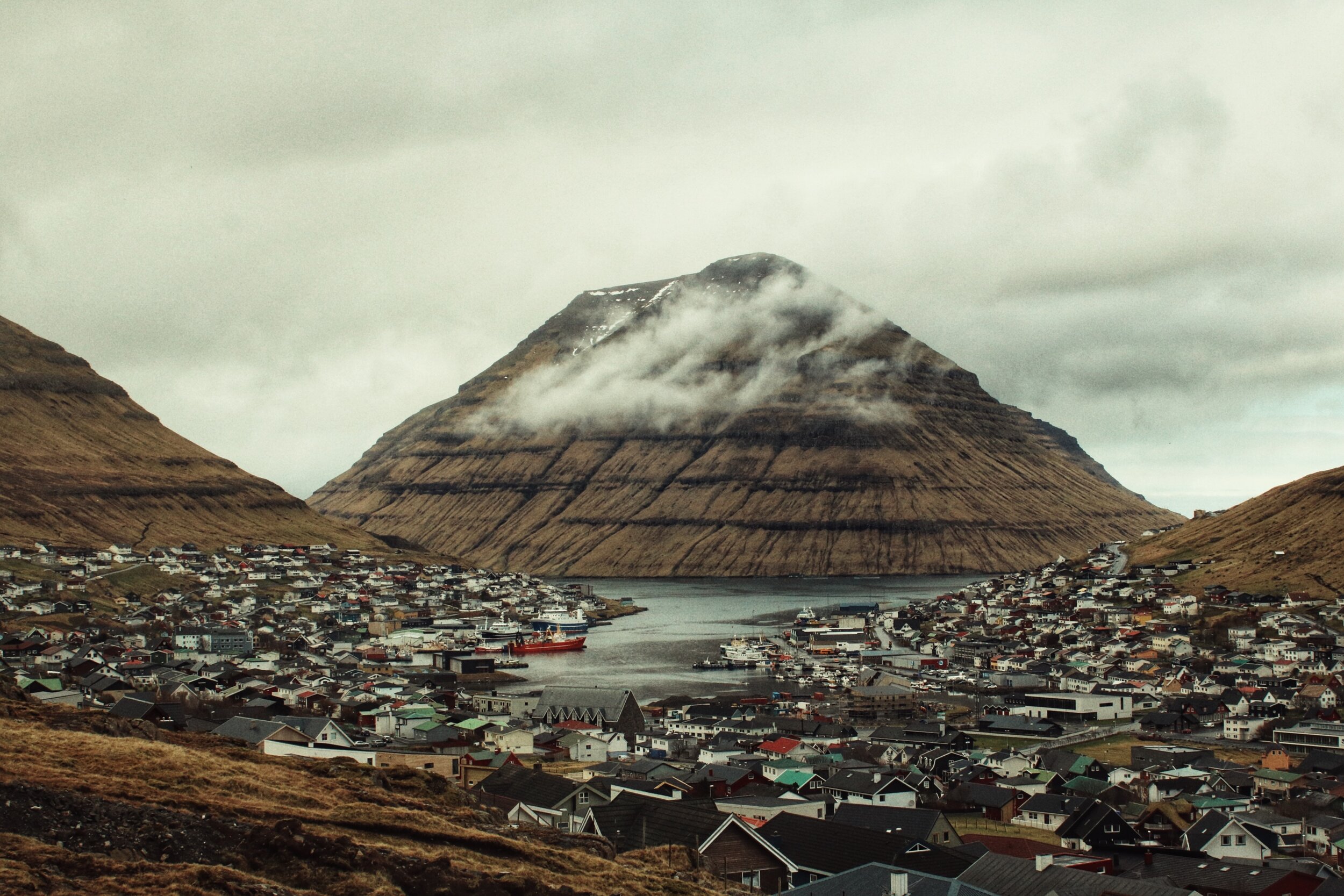
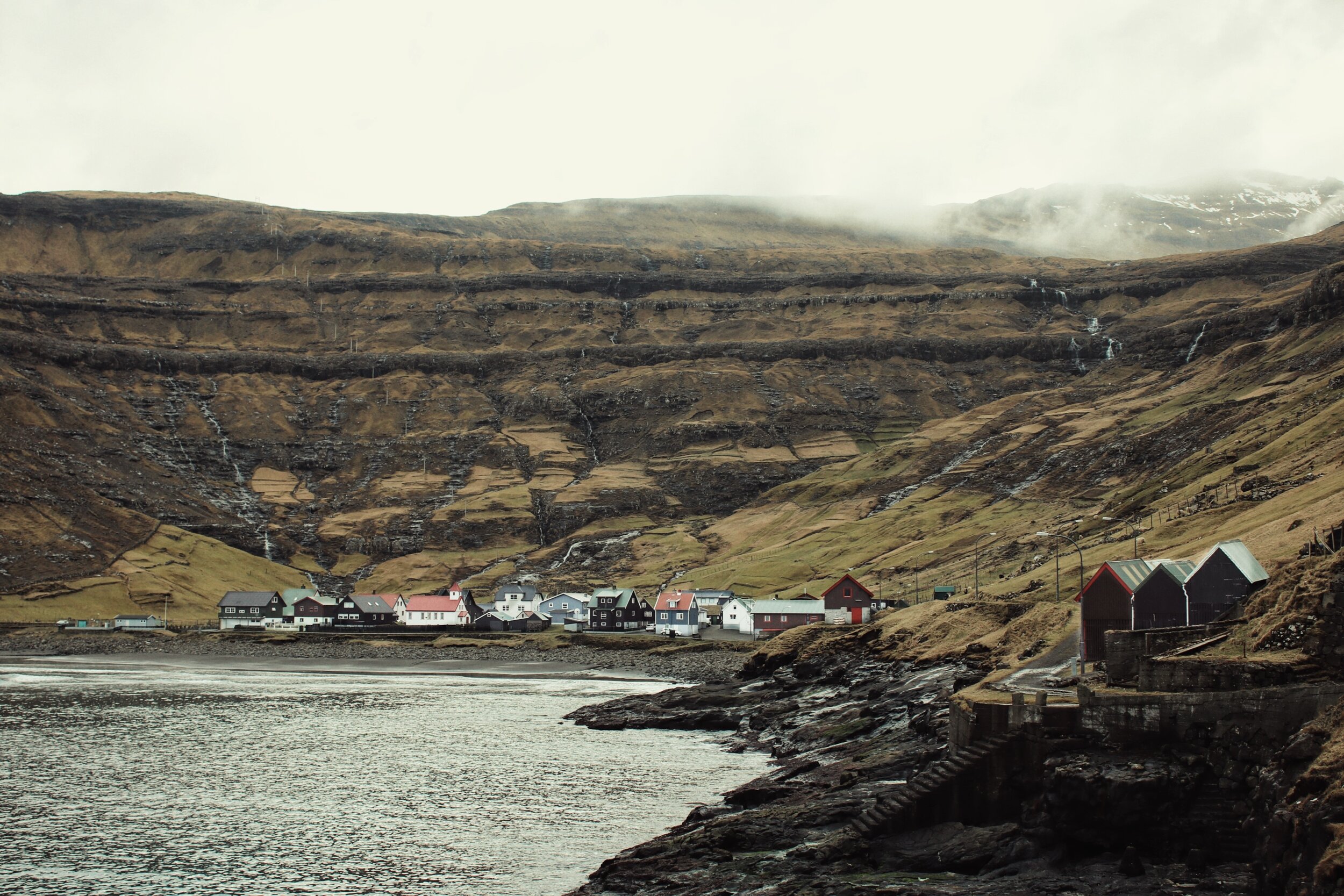
Klaksvik is the second largest town on the Faroe Islands and is situated on the island of Borðoy and this is where we’d call home for the next 7 nights. We checked in and headed straight out to explore our new home. We found a funky little place called Jacqson to grab some food before heading to Faroe Island’s best bar, Maverick. Or so we’d been informed. It just so happened that tonight was quiz night, perfect… If you spoke Faroese or perhaps Danish. Even still we joined in and the beautiful people in Maverick did their best to translate the questions into English, even if they really didn’t know more than 10 words. We learnt two things on this first night, the Faroese are incredibly welcoming and grateful to have tourists. Secondly, sailors in the Faroe Islands really know how to drink.


As morning broke we hopped out of bed in search of adventure, we had big plans for day one and wanted to dive straight in. We prepared our day packs and headed to the heliport. Travelling by helicopter in the Faroe Islands is an everyday occurrence, for a country spread over 18 Islands Helicopters are as important as buses in a city, the Faroese use these for commuting as well as doing the weekly shop. Our plan was to hop over 2 or 3 islands enjoying the aerial views of this incredible landscape before landing in Tórshavn and jumping on the bus back to Klaksvik. We were already running late when we realised the heliport wasn’t easy to find, it was early and still a little dark and the wipers on the car were in action. We made our way through the streets of Klaksvik but kept finding dead ends where we expected to find the heliport, as we began to panic we used our phones to route us to what looked like a heliport but our attempts failed. We even asked for directions which I think got lost in translation. With just 5 minutes before the helicopter was due to depart we found it, we parked the car, grabbed our packs and raced to what was essentially a shed in a field. Excited and now sweating we came to grinding holt when we saw a sign pinned up saying ‘Flight Cancelled’ we stood around in disbelief and tried to understand. On our first day of adventure this was a setback we’d never even considered. We were informed that the flight was cancelled due to poor visibility, the fog was a regular occurrence on the Islands. We hopped back in the car and started work on an alternative plan. Filled with disappointment and still sweating from the short sprint we headed to the neighbouring island of Kunoy which is connected to Borðoy by a causeway. Kunoy is the home place of the Faroe Islands National Anthem and now only consists of two settlements which are joined by a mountain tunnel from east to west. After a short stroll and bumping into a couple of local horses on the road side we headed back into the mountains and returned to Borðoy. Here we headed north along a gravel road to the abandoned settlement of Múli, not long after turning onto the track we became distracted by a huge waterfall cascading down the hillside to our left, we pulled over the car and started to scramble up towards the source of the water which turned out to be disappointing. We should have known better then to go chasing waterfalls and stuck to our plans and research, after wasting an hour we climbed back into the car and continued north towards Múli. This settlement has been considered abandoned since 2002, it felt like an end of the world film. These perfectly good homes in the wilderness still furnished but quiet and eerie.
We didn’t stay long and before heading to our next destination on today’s re-scheduled agenda, this was small village of Tjørnuvík which was about an hour from Múli, we headed south across Borðoy before crossing west across the island of Eysturoy and over a bridge to Streymoy then north along the east coast on Route 594, which, like so many roads on the Faroe Islands is just breath taking, yet slightly nerve wrecking when it starts to narrow on the descent into Tjørnuvík with a cliff face to your left and 100ft drop to the North Atlantic on the right. The view of this lone village nestled into the scenery is incredible, no other villages are in sight from here, just ocean and mountains, in fact it feels like the towering mountains wrap and hug around Tjørnuvík, we parked up and strolled along the beach with small waves crashing into the sand and through the small empty streets, we saw more sheep here than people. We continued beyond the village up a steep road climbing back out of the village where you have an incredible of view out into the North Atlantic and of Risin og Kellingin (The Giant and the Witch), 2 sea stacks just off the north coast of Eysturoy. Legend has it that the Giants in Iceland were envious of the Faroe Islands and attempted to drags these islands towards Iceland but alas they couldn’t move these firm mountains and as dawn broke the sun shone on the giants and turned them to stone and they’ve stood there ever since.
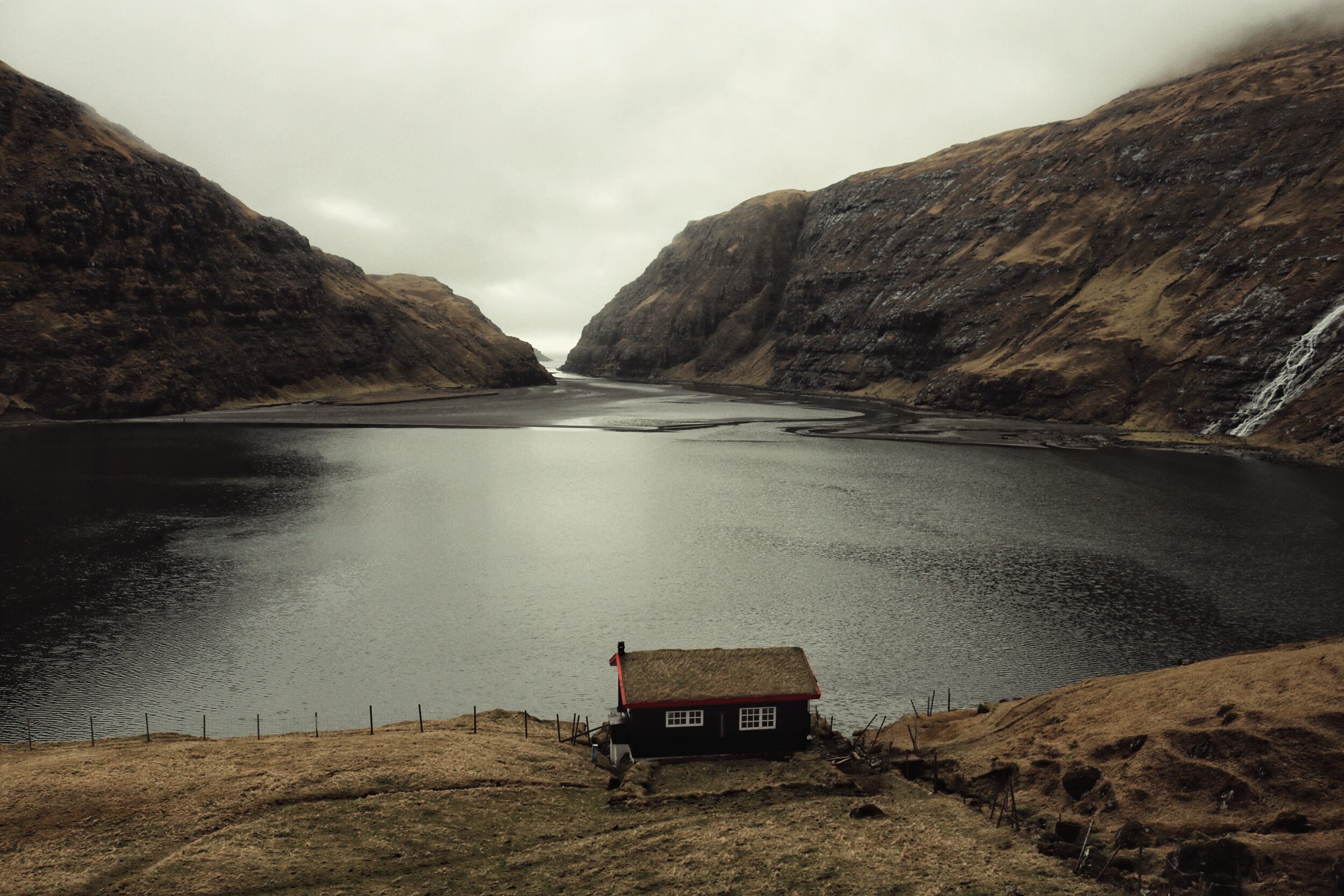
We headed south back on Route 594 before looping towards the North West side of Streymour up Route 53 along a valley base with imposing mountains flanking both sides of the road, this was the route to Saksun and one of my bucket lists places. If you’ve heard of the Faroe Islands then this is the photograph you’ve seen. A lone, tranquil cabin nestled into the hill, resting on the shore of a beautiful lagoon surrounded by majestic mountains and waterfalls with smoke gently rising from the cabin’s chimney on the iconic grass roof. It is utterly awe-inspiring and a view I’ll never forget. However what the picture doesn’t tell you is that it’s not easy to find, it’s completely hidden from sight and naturally there are no signs, we roamed the hillside, through fields and over small streams before catching a glimmer of the iconic red cabin and there it was, another tick for my bucket list. No photograph could ever really do it justice but that didn’t stop me trying. The other thing that I failed to read was that this was private land and we weren’t welcome, this was made fairly clear by the farmer who crossed the field on his quad bike and four dogs before politely telling us which direction to leave. So we promptly did and with that headed back to Klaksvik to our base.


We decided to ditch the car the next day and headed out on foot as we wanted to discover more about our home surroundings, we strolled down hill into town with breakfast on our minds and stumbled across what soon would become our go to bakery. Loaded up and full of energy we set off to climb to climb Mt Klakkur. The start of the hike winds up the mountain through the town and then along a track called Astarbravt which translates beautifully to ‘The Love Path’ from here to reach the Hálsur Mountain Pass. The hike took just over an hour in the wind and occasional rain and it’s a steady incline but as you’re approach the top you quickly forget the challenges and are struck by incredible 360 views, from here you can see the islands of Eysturoy, Kalsoy, Kunoy and Bordoy (The island we were stood on), the oceans, towns and of course the fog. Luckily we’d been told of a vital Faroese phrase “If the weather is bad, wait 5 minutes” and today this was very apt, whilst we soaked in the views from Klakkur we encountered rain, hail, wind, fog and the most beautiful sunshine and clear skies. The weather certainly has to be respected in the Faroe Islands and can be incredible dangerous but today we were able to enjoy the show.
The hike down from Klakkur was quick and easy however we did decided to cheat, as we reached the track and were able to get our friend Angus to pick us up. This still had its challenges as from the mountain side with views over Klaksvik, we had to direct him turn by turn to our location through the town which we hardly knew but it seemed to work until we saw him going the wrong way round a roundabout (Brits, ey). Eventually he found us half way up the road and we headed back to our apartment to rest up ahead of another big day.


We hit the road early and stocked up at the bakery today. We were adding another member to the team today and as we were heading back to the airport anyway we decided that today we’d explore the island of Vágar. After a swift pick up at arrivals we took the short drive to Sørvágsvatn Lake and set off on our hike. I sometimes wonder how I’d feel if I’d just got off a plane from Copenhagen put my suitcase in the car, said hi to everyone and within a few minutes of being here was lacing up my hiking boots to explore the wilderness of the Faroe Islands around a lake which is separated from the Atlantic Ocean only by a cliff face, it was an abrupt welcome to this wonderful place. As we followed the lake towards the coast the terrain was fairly flat, it’s a pretty easy hike and it only took around 45 minutes. As you approach the end of the lake the well-trodden path veers away from the lake and up a hill side towards the left, the incline was more challenging and slippery under foot but we soon made it to the top where we were nearly bowled by the incredible view and the wind. The wind can be extremely strong blowing in from the ocean, it’s enough to remind yourself you need to be sure footed and safely away from any cliff. We stood and admired the 30ft jagged cliffs erupting from the ocean which meet the lake. Waves crashing against the foot of the cliffs below a calm and still body of water. I’d never seen anything like this before, it’s hard to explain how epically beautiful it is. We sat and soaked in the views, enjoyed our picnic and chatted to other hikers before continuing around the cliff to lowest part of the lake where the waves were crashing into the cliffs and into the lake as the lake rises this is where it returns the water into the sea. It’s like natures version of tug of war. Incredibly we made a 90 minute hike last nearly 6 hours and it was worth every minute.
From here we headed east, back past the airport towards Gasadalur. The winding road hugs the jagged coastline with views of sea stacks and small islands teasing your wanderlust. Just before we reached Gasadalur we reached our next stop. Múlafossur Waterfall, an utterly beautiful natural wonder. This waterfall is fed by a small river running from high in the mountains before descending nearly 200ft into the Atlantic Ocean and is easily as stunning in real life as it is in the countless wonderful photographs it’s starred in. There is a uniqueness about seeing a river flowing straight off a cliff face and crashing into the sea and we could feel the sea spray from the opposing cliff as we watched the water blow back up the cliff. As we stood alone in awe at this majestic site the rain started to fall in true Faroese style, we sheltered and waited 5 minutes and once again the weather passed and the clouds began to break we were then joined by a German photographer who we had met earlier that day at Sørvágsvatn Lake, his English in all honesty was better than mine, as were his photographs, but this wonderful stranger was kind enough to help teach me a few things and even leant me some of his equipment to help me capture the ‘money shot’ of the waterfall. We shared Faroe Island experiences before parting ways but it’s a moment I’ll always have fond memories of. The kindness of a complete stranger, on a cliff side in the wilderness somewhere in the Atlantic Ocean truly keeps my faith in humankind.
After what was already an amazing day we headed to the countries capital, Tórshavn. We had a tip off that there is a restaurant here with some of the best sushi in the world. Tórshavn is home to around 14,000 people which is approximately 26% of countries population and is officially one of the smallest capital cities in the world but this small city is still renowned for its hipster bars, local designers and world class food scene. Tonight we were headed to Etika Sushi where they blend Japanese cuisine with fresh Faroese fish to astonishing effect. We ate incredible and sensational food, drank and talk about our day of adventure. This was one of the best tips I’ve ever had.


The following day after a late night and a few too many drinks we headed out late in the morning towards the northwest tip of Eysturoy to a small village called Gjógv. It was a grey, drizzly day as we crossed the sea tunnel and headed west on Route 10 before turning off and heading north. Once again we were blown away by another epic drive as we hugged the Funningsfjørður fjord as the mountains loomed over us from the opposite side before winding up mountain sides - to the displeasure of those affected worst by the drinks and late night. Luckily I was fine and was loving this drive as we wound up and down mountains before reaching Gjogv.
Gjogv takes its name from the beautiful sea filled gorge which runs from the village to the sea. Once a popular village, Gjogv now only inhabits less than 50 people. Our first stop was to a hotel where we grabbed some lunch and the owner told us that due to the villages remote location if there weather turns the only route in can be un-driveable so over the last 10 years its inhabitants have been relocating to Tórshavn for work. The hotel was eerily quiet, it felt like we were the first guests that have visited in the last year but the food was good and just what we needed. We then took a stroll around the village through the timber walled houses with turf roofs and found the stunning gorge which gives its name to the village. The rain continued to fall as we cut our exploration short and got back on the road.
The road from Gjogv to our next stop, Eiði is one of the best on the island and passes over the Faroe Islands tallest mountain, Slættaratindur. The winding roads and incredible views are truly unforgettable. Eiði seemed nice but we were heading to an iconic spot just outside the village, the road wound through the village before bordering Lake Niðara Vatn towards the North Atlantic Sea. Just where these two bodies of water meet is one of the most stunning and remote football pitches on planet earth. Surrounded by mountains, a lake and the North Atlantic this pitch is wonderfully picturesque. The rain continued to fall and the wind was ferocious but we braved the elements and headed on to the pitch. Sadly no one plays here anymore and it’s actually more commonly used as a camp ground for caravans, there were even swings on the goal posts now. After getting soaking wet once again we bailed and got back into the car we decided we’d make one more stop and return back to Klaksvik.
Our last stop was a return to Saksun, after being scared off by the local farmer and his dogs we left prematurely and didn’t get much chance to look around the tiny village. Saksun has some of the best grass roofed houses in the Faroe Islands so we felt obliged to check out what we’d previously missed and we knew we wouldn’t be back in this part of the islands again. It rains 300 days during the year in the Faroe Islands so early settlers introduced the grass roof as a way of providing protection from the rain and great a thermal insulations although building methods have changed these roofs remain an iconic symbol of the Faroese history.


Another adventure took us to the southernmost tip of the island Streymoy to visit the historical village of Kirkjubøur. As we arrived the rain and wind joined us, large waves crashed over the harbour and into the car pack. Here we explored the 11th century log house, Roykstovan which is partly still open to the public and we dashed around the ruins of Magnus Cathedral and Saint Olav’s Church trying to not get too wet. Most of the houses here were painted black and had the iconic turf roofs, soaked in the rain water.
As the rain began to halt and the clouds cleared we made a break for our next stop. We spent countless days back in England practicing for this day, as we drove north I felt nervous and a little apprehensive. I was about to try something new, something I’d never really done before, downhill skateboarding. I get that to most people it might not be daunting but you have to consider that this is an accident waiting to happen, I never learnt to skateboard as a kid but the road is a skateboarder’s dream and I like to dream. The road is off Route 10 heading towards Norðradalur, it starts high on the mountain side before tightly winding and bending down towards the village where it meets the ocean and in the distant, glowing in the sunlight, is the island of Koltur. We admired the view of the road and took a few photographs whilst building up the courage the break out the board, which we crammed into our luggage. However, within minutes the rain clouds had caught up with us and the heavens once again opened. We attempted a couple of runs on the penny board but with the wind, rain and lack of ability to skateboard it was pretty unsuccessful. The light which fell on the island of Kolkur was now a dark cloud so before long we raced back into the car for shelter.
From here we headed to civilization and back to Tórshavn. We wanted to explore some of the independent shops and local designers this time. We stumbled across Öström which was a design store full of beautiful Faroese and Nordic design and the place where Lucy started her new tradition of collecting a ring from all the countries we travel to - A tradition that comes at some cost but the ring we found was beautifully Farorese and something that will always remind us of these great adventures. The weather was still miserable so we took shelter at Brell Café and refuelled on coffee and cake.
After another damp and rain filled day we made an impulse decision to dry off with pizza and bowling on route home, something we didn’t expect to see on these islands. The pizza was great, the bowling alley only had 6 lanes and we were the only customers but was fun and most importantly dry, it was also close to Klaksvik in a village called Leirvík which was situated just on the other side of the sea tunnel on Eysturoy. After making it back to Klaksvik we decided to head back out to our new favourite club, Maverick where we met more locals who seemed suprised but excited to have tourists. It was great getting to know some of the locals who told us a lot about live in the Faroe Islands, I’m not sure how but we even got on to the subject but ended up discussing Tinder and how in the Faroe Islands you really swiped until you found someone you didn’t know or aren’t related to and how first dates consisted of helicopter riders and hikes. Worlds apart from Netflix and Chill.


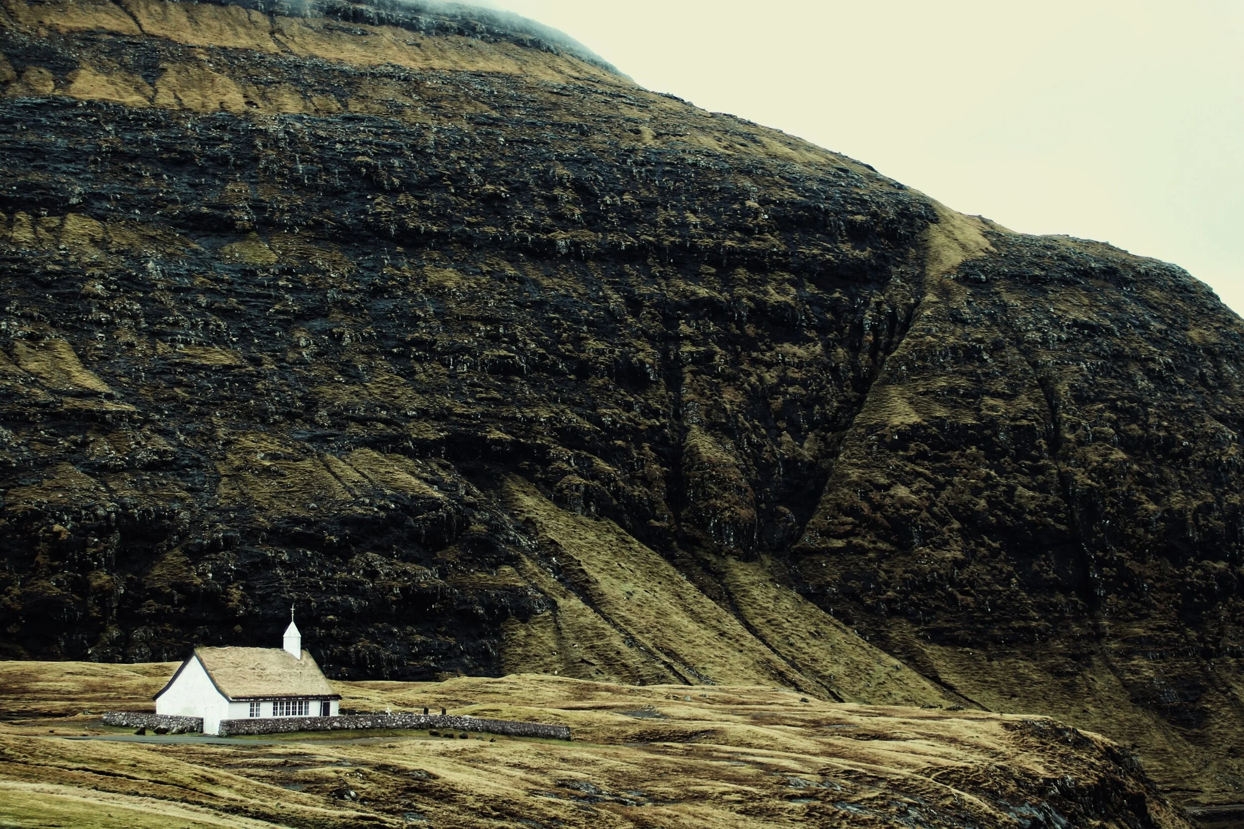
On our penultimate morning we headed back into Klaksvik and explored some of the local shops, restaurants and bought a few traditional souvenirs including some Faroese wool which I gave to my Grandma, who loved to knit. We grabbed brunch at Fríða Kaffihús which was situated right on the water and tried traditional Faroese Tapas which included fermented meats, this was an acquired tasted. We re-grouped back at the apartment and then headed north, the island of Vidoy stretches further north than any of the other 17 islands and we were headed to the village of Viðareiði, which not surprisingly is the northernmost settlement in the Faroe Islands. From Klaksvik we headed east on Route 70 and crossed a small sea bridge from Bordoy to Vidoy at Norðdepil a small harbour village with separate settlements either side of the causeway which act as one community. From here we kept to the west of Vidoy along the old route 70 which has recently been replaced by a new mountain tunnel connect the west and east coasts of Vidoy. Route 70 was deemed unsafe due to landslides and avalanches. We followed the road as far as we could before it became a small gravel track, enjoyed the views and headed south and through the new mountain tunnel as we exited the mountain we were greeted with even more beautiful coastal views, the new road swept across the landscape like rollercoaster, it was a stunning to drive, to our east we had coastal views and back drop of the easternmost island of Fugloy and to our north was our destination nestled at the foot of the Villingdalsfjall Mountain which stands proudly at nearly 3,000 ft. We parked up in the village and trekked west around the base of the mountain towards the coast. From here we headed south towards a beautiful, small church were we had incredible views across the ocean to Bordoy and to one of our previous locations, the abandoned settlement of Muli. After enjoying the views and dodging a handful of rain showers we headed back towards Klaksvik.
Our last day filled with the usual rush and panic, Klaksvik quickly and very easily felt like home and now suddenly we had to cram everything back into cases and backpacks, we left the apartment with plenty of time before our flight as we had hoped to revisit one of previous destinations. After the disappointment of our unsuccessful skateboarding adventure we felt we needed one more shot at it. So with high hopes we returned to the top of the winding road only to be greeted with heavy black clouds and the splattering of rain drops on the car. It was our last day so we knew there was no more chances, this was it. Get wet or fail. Or in our case both, we braved the rain and gave it our best shot but I think we need a little more training, we certainly aren’t ready for the half pipe yet. From here we headed towards the airport and just had one stopped left to make, we needed to refuel the car before handing it back. Refuelling the car, or stopping at any service station was something we were always excited about as this is where we discovered the best hot dogs I’ve ever had. These hot dogs were hot and fresh but also had the baguette hollowed rather than sliced which is genius as the sauces remains in the baguette. We tried many hot dogs but my go to flavour was the French-Style hot dog and every hot dog I’ve had since the Faroe Islands has the unfortunate challenge of being compared to these hot dogs. So far no hot dog has dislodged the Faroe Islands on the leader board.
We left the Faroe Islands the same way as we arrived, staring out of the airplane window, where through broken cloud we could see the unique and dramatic landscape erupt from the ocean. With views of waves crashing against huge mountains covered in a mossy green coat causing our jaws to once again drop from its usual position as we departed the islands we had the pleasure of calling home for 7 days.

